ArcGIS Online enables you to connect people, locations, and data using interactive maps. Using ArcGIS Online, you can work with smart, data-driven styles and intuitive analysis tools that deliver location intelligence.
You can use ArcGIS Online as a standalone solution for your mapping and analysis needs. Or, because it’s an integral part of the ArcGIS system, you can use ArcGIS Online to extend the capabilities of ArcGIS Desktop, or ArcGIS Enterprise, or build custom apps using ArcGIS Web APIs and SDKs. ArcGIS Online also provides access to the ArcGIS Living Atlas of the World, a vast collection of curated, authoritative, ready-to-use content from Esri and the global GIS user community.
Don’t have an ArcGIS account? See Create an ArcGIS Account.
March 2020 release
ArcGIS Online is updated regularly, and this latest release adds many useful new features and enhancements. The March 2020 update includes 3D visualization enhancements, a redesigned user profile experience, and other improvements and new functionality.
Other products are released on independent timelines but are part of the online ecosystem. This article summarizes those developments that have occurred since the December 2019 ArcGIS Online release. For additional details see the What’s new help topic, view all posts related to this release, or view specific product blogs.
Featured this release
3D visualization
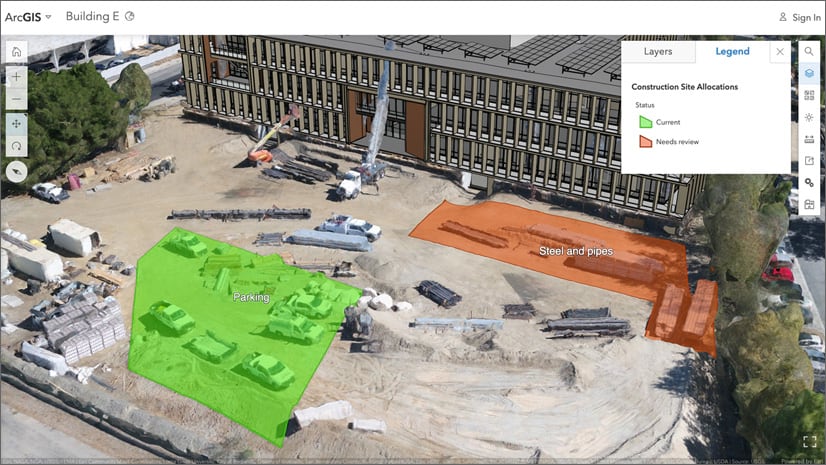
You can drape feature layers onto integrated mesh scene layers for better 3D visualization. This enables you to gather a recent 3D snapshot of an area of interest with Drone2Map for ArcGIS or SiteScan as an integrated mesh scene layer and easily mark locations with points, lines and polygons, as shown in the construction scene below. Set the elevation mode to On the ground for feature layers.
You can now label 3D object scene layers based on an attribute, such as the building name or address.
The Building explorer tool has improved filtering options for building scene layers. Using a new filter you can choose which construction phase to show. For example, you can choose a specific construction phase to display all the components created during the phase and before. The Building explorer tool also has improved visualization when the level picker is used; the bottom levels now appear semitransparent for added visual context.

Profile page
The user profile and settings experience has been redesigned, allowing you to showcase yourself and your content through the refreshed user profile page. A separate user settings page makes it easier to view your licenses, credits, and manage various account settings at once. If you are licensed with ArcGIS Pro, now you can easily download it from licenses of the user settings page. For more information, see Refreshed user profile page.

HTTPS readiness
Some organizations activated before September 2018 still allow ArcGIS Online to communicate using HTTP access to content, such as web layers and images. As of December, 2020, HTTP support will be discontinued and references to HTTP URLs will no longer work in ArcGIS Online.
As part of the March 2020 update, ArcGIS Online notifies users about the upcoming change when references to HTTP content are submitted.

It is recommended that organizations verify their security settings as soon as possible and make the necessary changes to content and workflows before December, 2020. For more information about considerations when making this change, see the Important Updates for the ArcGIS Platform and HTTPS Only Enforcement Support article.

ArcGIS Online Security Advisor
ArcGIS Online Security Advisor provides a full run-down of your organization’s security settings at the click of button, eliminating the need to review settings one-by-one administratively. Security Advisor also delivers recommendations based on your current settings.
Built by the Esri Software Security and Privacy team, you can launch the app from the ArcGIS Trust Center, where you will find other useful information, alerts, and announcements.
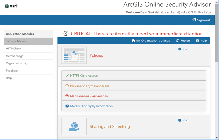
Enhancements in this update include:
- Any member can use the HTTP Check module.
- For web map item types that are identified as having HTTP links, the HTTP Check will provide a link back to ArcGIS Online where users may update the layers to HTTPS.
For more information see ArcGIS Online Security Advisor, or visit Esri Software Security and Privacy on GeoNet.
Other enhancements
Map Viewer Beta
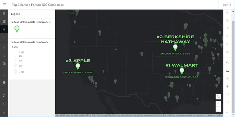
Several enhancements have been added to Map Viewer Beta since the last ArcGIS Online update. Highlights include enhanced label authoring with support for multiline labeling, scale-dependent labels, and rotation. To learn more, see New labels in Map Viewer Beta.

Sharing and collaboration
You can now use filters to help you find specific groups with which to share your content. For example, choose the Special Groups > Shared Update filter to display only shared update groups, or find other types of groups such as administrative or featured item groups. You can also filter by owner or group creation date.
You can also embed videos in item page and group page descriptions. This allows you to provide additional information, context, and instructions about your items or groups.

Configurable apps
Configurable apps are template applications that you can configure easily, without any coding. They help you publish apps quickly for a variety of users and workflows. Configurable apps are the fastest and easiest way to go from a map to a shareable app.
This release introduces a new Minimalist (beta) configurable app. Minimalist (beta) is built using the 4x version of the ArcGIS API for JavaScript. The app offers an updated user interface and support for newer functionality such as multi-component popups and dot density rendering. Also included is a revamped app configuration that provides a more efficient and streamlined configuration experience. For more information, see What’s New in Configurable Apps (March 2020).

Data management
When purchasing an ArcGIS Online organizational subscription, you can now choose the region—United States or Europe—where your geospatial data will be stored. The option to choose a regional data hosting location is available for subscriptions purchased after the March 2020 update of ArcGIS Online.
For organizations activated before this date, all geospatial content and user information is stored in the United States. The regional data hosting location is displayed for new and existing organizations on the Overview tab of the organization page. See What is regional data hosting to learn more.
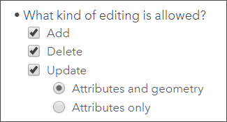
Streamlined Edit settings on hosted feature layers and hosted feature layer views allow you to control the types of edits others can make to your layer, including allowing or disallowing edits to feature geometries.
The size limit for files uploaded to ArcGIS Online has increased from 200 to 500 gigabytes.
You can replace the contents of a scene layer you publishedfrom a scene layer package. This allows you to maintain the existing scene layer’s item ID and URL, which means the scenes and apps that contain the scene layer will have access to the updated content without you republishing the layer.
A new feature layer template is available for collecting tabular data, such as sales data.

Accounts and administration
In addition to Facebook and Google, a new social login optionis available in ArcGIS Online. Developers and other GitHub users can sign in or sign up using their GitHub account credentials. See Sign in with a social login for more information.
When you set the language for your organization, you can now specify a number and date format for three additional languages—French, German, and Italian. Individual organization members and those with public accounts can also change the number and date format through their profile page. For example, if the language is set to French, you can display dates and numbers using the formats defined in the Common Locale Data Repository (CLDR) for France and Switzerland.

ArcGIS Notebooks (beta)
ArcGIS Online organizations can create notebooks using the new beta version of ArcGIS Notebooks. ArcGIS Notebooks integrate Jupyter, the popular open source Python notebook format, directly within ArcGIS Online. Notebooks are an efficient, modern environment that combines code, on-the-fly visualizations, analysis tools, and maps. They are also very useful for automating administrative tasks, such as managing users and content.
ArcGIS Notebooks has been optimized to allow the easy addition of data and analysis tools as code snippets. In addition to the standard analysis tools of ArcGIS Online, Notebooks deliver options to work with the ArcGIS Python libraries, and open source Python libraries.
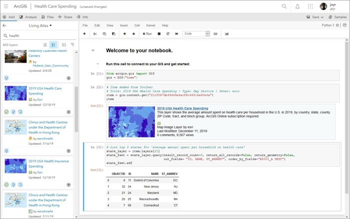
Notebooks are now available in ArcGIS Online via a public beta. During the beta, normal credit rates apply for running analysis, accessing premium content, and storage.
Administrators will see Notebooks as an option in the top navigation pane and can begin using them immediately. Organizational members will require additional privileges before they will be able to start working with ArcGIS Notebooks.
For more information about ArcGIS Notebooks Beta, see ArcGIS Notebooks Beta – Online on GeoNet or ArcGIS Notebooks public beta is here.

ArcGIS Companion
ArcGIS Companion makes it easy to use ArcGIS from your mobile device to explore content, view groups, edit your profile, and more.
The latest release includes support for the new Storyteller user type and support for Enterprise 10.8. For more information, see ArcGIS Companion on GeoNet or What’s new in ArcGIS Companion 3.1.
ArcGIS Living Atlas
ArcGIS Living Atlas of the World is the foremost collection of geographic information from around the globe. It includes curated maps, apps, and data layers from Esri and the global GIS user community that support your work. Visit the ArcGIS Living Atlas of the World website where you can browse content, view the blog, and learn how you can contribute. Here’s what’s new, been recently released, or is coming soon.

COVID-19 has focused the world’s attention and one of the authoritative sources to monitor its progression is with the Coronavirus COVID-19 Dashboard by Johns Hopkins University. Using Living Atlas of the World live feeds methodology, and built using ArcGIS Dashboards, it delivers the latest information from around the globe.

National Urban Change Indicator
The National Urban Change Indicator (NUCI), developed in collaboration with Maxar Technologies, provides a 30-year history of persistent land cover changes for the conterminous United States. For more information, see 30 Years of Human-Related Change.

New OpenStreetMap (OSM) layers
New OpenStreetMap layers are now hosted in ArcGIS Online and available in the Living Atlas. These feature layers allow you to access the latest OpenStreetMap data (e.g. buildings, highways, and amenities), created and edited by OpenStreetMap contributors, for visualization and analysis. The initial set of layers (now in beta release) are available for North America, with additional layers and regions to be added soon.

Demographics
The American Community Survey (ACS) is an ongoing survey by the U.S. Census Bureau. It compiles information such as ancestry, citizenship, educational attainment, income, language proficiency, migration, disability, employment, and housing characteristics.
Last December 78 Living Atlas layers containing American Community Survey (ACS) data were updated within 48 hours of Census releasing the 2014-2018 values. These layers are grouped by topic, such as health insurance, internet access, and living arrangements, and can be found in the American Community Survey (ACS) group.
Additional highlight layers have been added including:
- ACS Population and Housing Basics (centroids and boundaries)
- ACS Context for Child Well-Being (centroids and boundaries)
- ACS Context for Senior Well-Being (centroids and boundaries)
- ACS Context for Emergency Response (centroids and boundaries)
For more information, see Industry-specific ACS layer now in ArcGIS Online.
